| |
Very few foreigners have any idea of the great extent
of Iceland. One would not suppose that the size of this
island in the North Atlantic is 104,785 square Kilom. in other
words about three times the size of Denmark and larger than
the habitable coasts of Greenland. The island is one great
highland, varying from 5001000 meters in height upon
which there are small plateaus. The extent of the Lowlands
is only one fifteenth of that of the Highlands, so they are com-
paratively small, but of the greatest economical value, as there
are hardly any other inhabited places to be found.
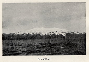
Öræfajökll.
The highest mountains in the interior lie in a line from
N. W. to S. E. These are however no connected range, but
a row of ice and snow capped cupola shaped summits, which
are separated by dips. These cupola shaped summits, rise
(as the Geologist Thoroddsen has proved) from the main
plateau to the height of 14002000 meters and lie 600900
met. above the interior highland. The most easterly of these
summits is the great Vatnajökull with Oræfajökull, its mass
of ice covering an area of 8,500 square Kilom. The
Vatnajökull is separated from the Tungnafellsjökull by Vonarskard
1000 m. high. Between the Tungnafellsjökull, and the
Hofsjökull lies the broad dip, Sprengisandur 650 m. To the west
of the Hofsjökull and between that and the Langjökall, lies
Kjolar or Kjalvegur 600 m. Between the Langjökull and the
Eiriksjökall, Flosaskard 800 m., and between the Langjökull
and the Ok, Kaldidalur 700 m. The table-land N. of the last
mentioned snow mountains, some of which abound in lakes
and bogs, have different names, such as, the Storisandar,
Grimstungnaheidi, Arnarvatnsheidi, Tvidasgra and Holtavorda-
heidi.
In the highland there are many valleys through which the
ramifications of the mountains extend towards the sea.
The highland of the interior consists chiefly of wastes,
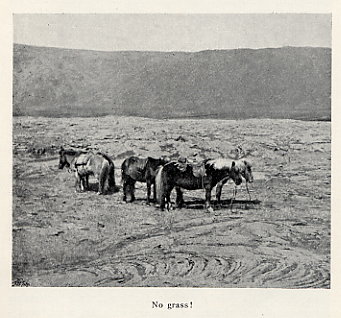
No grass!
where no grass grows, but the condition of their surface
varies somewhat, according to the geographical nature of the
fundamental mountains, where Basalt and Dolomite form the
substratum, the surface is covered with irregular shaped
rocks rent asunder by the frost. A ride in such regions is
consequently most difficult. Where Tuff and Breccia are
found, the surface consists chiefly of gravel and scoria,
which through decomposition has loosened from the
Breccia; riding here can be very hard work. The lava fields
cover a very large area, being almost without vegetation and
it would be difficult to find a more desolate sight. As far
as the eye can reach, the surface is covered with a hard
jet-black mass; there is no sign of life, and the silence
of nature is depressing. The largest tracts of lava in
the interior are Odddahraun N. of the Vatnajökull 3500
square Kilom., Kjalhraun on the Kjalvegur, and
Hallmundarhraun between the Langjökull and the Eiriksjökull.
Besides the cupola shaped jökulls, there are to be found here
and there on the highland, solitary high mountains, for
instance N. of the Vatnajökull; the Herdabreid 1660 m. high;
the Sncefell 1822 m. and the Dyngjufjull 1400 m., a large
volcanic group, with the crater valley Askja. S. W. of the
Langjökull, the Hlödufell 1163 m., and the Skjaldbreid 1063 m.
Mountains and peaks appear here and there on the
borders of the jökulls (glaciers) and among these the volcano
Oræfajökull 2119 m., Icelands highest and most
important mountain.
Iceland's glaciers surpass in size many of those of the
European Continent.
Thoroddsen has described the 139 large and small glaciers
found in Iceland. In Greenland the traveller may picture
himself transplanted to the ice period, whilst in Iceland he
may sooner imagine that he is in a post-glacial period in
which the masses of ice have decreased. The area covered
by the glaciers of Iceland is very extensive viz, 13,500 square
Kilom. The following serves as a comparison: the Alpine
glaciers are only 3000 square Kilom., the Norwegian glaciers
are about the same size as those of the Alps, the Swedish,
400 square Kilom. and those of the Caucasus 160 square Kilom.
According to Thoroddsen, the large glaciers in the interior
of Iceland lie on Tuff and Breccia.
As the land is chiefly composed of volcanic and basaltic
mountains, dark shades of colour are the most
predominant in the landscape, more especially where there is
nothing but basalt.
In a country like Iceland, with a damp climate, and many
large glaciers there are of course many rivers with large
volumes of water. Some of the largest are, the Hvítá (called
Ölfusá towards the end of its course) the Thjórsá, the Jökulsá,
in the Axarfjördur etc. These are so mighty that they can
compete with the Rhine at its middle. The glaciers in the
interior serve as immense reservoirs from which most
of the rivers are supplied, and as they constantly attract rain
and moisture the supply is always regular.
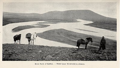
Hvítá North of Gullfoss - Bláfell (near Hítárvatn) in distance
The Icelanders make a distinction between "bergvatn"
(vatn-water) clear water which does not come from the
glaciers, and jökulvatn, milky water from the glaciers.
The ice and snow melt at the base of the glaciers
and there form swamps and pools of water, which find
an outlet in many streams and rivers. The watershed
between them is often almost imperceptible. The streams
form large rivers, the milky glacier water of which, rushes
down in torrents towards the sea. Gravel, quick-sands,
rocky wastes and fields of lava form the surface of the
highland, which is of a peculiar beauty. For one who, like the
Author, has frequently traversed these wastes on
horseback, the attraction becomes greater and greater. No one,
who has not ascended the highlands from the deep,
perhaps foggy, dales, can form an idea of how beautiful it
is at the top, where one suddenly discovers the glittering
snow in the distance, where one must ride for days over
rocky sands, or steal across the jet-black lava fields; where
one must cross the treacherous glacier-rivers, and hasten on,
to the few and scattered grass-plots, Iceland's oases, in order
to procure fodder for one's horse. During 22 1/2 months
there is a little grass on these oaces, which at the height of
500 meters are for the most part very small, and often in
connection with hot springs. They can supply a few horses
with fodder for some days, should they be covered with
grass. On leaving, all the grass is consumed, and no more
horses can graze there that summer. Some oaces are often
overgrown with moss, and only useful as pasturage for sheep,
in which case the traveller must therefore have a supply
of hay with him.
The Lowlands and valleys are, as already mentioned, the
inhabited places, and only a few farms are found on the
outer declivity of the highland. The few somewhat extensive
and inhabited tracts which lie rather high, are the
Mývatnsveit 300 m. above the level of the sea, the
Mödrudalsfjöll 4500 m. and the Jökuldalsheidi 500530 m. The
means of subsistance of the inhabitants of these elevated
settlements (Bygdir) consist almost exclusively in the
breeding of sheep, and perhaps a little fishing in the lakes. The
Mödrudalsfjöll (fjöll-group of mountains) is chiefly covered
with loose sand, and here the sheep get nothing but
Elymus arenarius and Salix glauca, but they thrive very well
on it.
In the Saga age, the interior of the country was more
inhabited than at the present time. At a very early period
the Norwegian settlers tried to subsist right in the interior
of the highland; but they soon discovered that the climate
there was too severe. The cold was too great in winter;
the immense quantity of snow prevented the cattle from
finding food, and in the short summer, sufficient fodder could
not be procured for the winter. The Mödrudal's average
temperature for instance is: Minus 0,8° C.
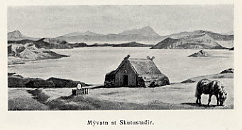
Mývatn at Skutustaðir.
Several settlements in the high altitude soon disappeared
after the Plague had ravaged Iceland from 1402 to 1404 and
caused the ruin of many farms. Besides this, there were
many volcanic eruptions, drifting sands, glacier torrents
(Jökulhlaup) etc. etc. consequently many settlements in the
highlands, and on the outskirts died out. They are known
Myvatn at Skutustadir.
by the ruins of farms and houses, which appear when the
volcanic sand and ashes that cover them drift away. Geitland,
which was situated to the W. of the Langjökull, was destroyed
already in 1185. In the 14th Century the famous
Thjorsárdalur, ..Iceland's Pompeii", was destroyed by an eruption of
the Hecla.
There were also farms in the district S. of the Hofsjökull,
and in the vicinity of the beautiful glacier-lake Hvitdrvatn,
into which the Langjökull empties its glaciers. There were
also settlements in the valleys N. of the Hofsjökull, down
towards the Skagafjordur, as well as in several other places.
Here the author has made interesting investigations, which
throw light upon the state of civilisation in Iceland in olden
days. As a rule, no one lived in the interior of the high-
land proper, where the climate was inhospitable and severe.
But it sometimes happened that outlaws fled to the highland
where they led a miserable life in summer, fishing trout,
or stealing the peasant's sheep which grazed on the pastures.
These fugitives were the original cause of the extraordinary
popular opinion, that colonies of "Utilegumenn" (outlaws)
existed in the highlands, a credance, prevalent among the
lower classes up to the present time.
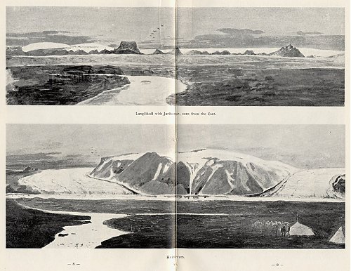
upper: Langjökull with Jarlhettur, seen from the East
lower: Hvítárvatn
When the wind blows over the highland in winter, it
seems as if all life were extinct, only the Aurora Borealis
gleams in the sky with rapid varying streams of light. In
summer, the whistling notes of plovers and curlews are
heard on the tableland. Swans, geese, and other web-footed
birds breed in the lakes, and thousands of sheep and lambs,
some young cattle and colts, make their way to the interior
of the country in search of food.
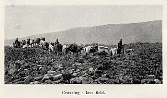
Crossing a lava field.
It also happens, but only at long intervals, that horse ca-
ravans cross the country and the foot-prints of the animals
remain long ineffaceable.
There is no sound of rolling carriages nor the baying of
dogs in the distance, and no smoke rises from human dwellings.
There is perfect peace. Only now and then the hoarse,
warning and weird cry of a raven is heard across the plain, or
in the valleys. To day, as it did a thousand years ago, the
everlasting ice glitters on the beautiful mountains, seen on the
horizon.
In spring-time, the people from the farms in the valleys
bring the sheep and lambs to the foot of the highlands, and
in small flocks the animals go further towards the interior,
following the banks of the rivers, or the boggy mossgrown
dips. These animals wander slowly towards the glaciers,
and right into the valleys between them, a solitary sheep,
or small flocks often being met with in these regions. In
the bright sunshine they appear as white patches on the
dark sands, the mountain slopes and in the deep valleys; so
that they are visible even at a great distance. To the unac-
customed eye, it is impossible to discern any food on the
spots where the lambs understand to find it. Here and there,
there are places (as a rule, boggy tracts) near the rivers,
which, seen from a distance, appear to be splendid meadows,
but which, on nearer approach prove to be covered with hardly
anything else but moss. The sheep graze on the highlands till
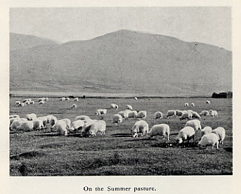
On the Summer pasture.
September, when trained men look them up, and drive them
home.
The interior of Iceland, quite up to the glaciers, is divided
into joint-pastures (afrjettir), bearing the name of the districts
to which they belong. The lambs often find their way from the
one pasture to the other, therefore the ears of the sheep
from the different farms are marked, and in this way it can
be seen to which farm they belong. On certain days the pea-
sants meet in order to exchange such sheep as they may
have got hold of by mistake.
The peasants must, as a rule, go up to the mountains two
or three times to drive home the sheep. From the end of
September, when the snow-storms begin and the snow lies
high, it is impossible to go about in the interior.

Assembing to collect the sheep from summer pasture
These trips to the mountains are systematically arranged,
and the search is carried on, on certain lines. They make
first for the most remote parts, whence the sheep and lambs
are driven down along the streams and rivers to the inha-
bited districts. On these excursions the people must pass
through, and even spend a night, in places where no grass
is to be found for the horses, and consequently they must
have a supply of hay with them.
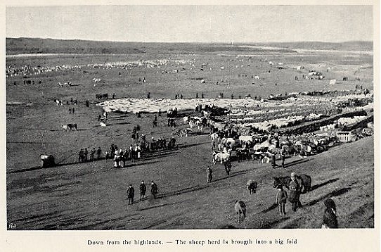
Down from the highlands - The sheep herd is brought into a big fold
This means many a brisk and fatiguing ride for the young
men, but it is always looked upon as a pleasure. In the eve-
ning, after these excursions, the peasants assemble in their
small portable tents, or in one of the miserable huts to be
found in the highlands; there they sit huddled up in order
to protect themselves against the cold, and while the kettle
boils, they sing, drink coffee (they have no brandy with them)
and seem to enjoy life in the mountains. After a few hours
sleep, they mount their horses again.
Every evening they drive the sheep they have collected a
good distance on the way towards the "Bygd" (settlement). The
next day they continue their ride until they have collected
thousands of sheep. With a deafening noise, they are driven
into big folds, where they are sorted out and sent on to the
farms to which they belong. This lasts several days and is
a national festival, at which lots of people are present, both
men, women and children.
For those wishing to travel through the interior, the grea-
test obstacle, is the want of pasturage for the horses; there
is another great difficulty, viz: the dangerous crossing of the
glacier-rivers, where one may perish in the quick-sands. The
fog too, is a dangerous enemy. One must advance to obtain
grass for the horses. If you lose your way, you are placed
in a great dilemma.
Down to the present time, roads in Iceland, even in the
inhabited parts, meant, as a rule, only certain directions in
which one could ride; they were indicated by paths, some-
times deep, and which often disappeared in stony ground.
There were very few bridges, one proceeded as well as
one could, through bogs, rocky regions, or sandy rivers.
In later years the means of communication have been
greatly improved in the inhabited parts of the country,
and something has also been done for the interior. There
were passes here, between the glaciers from olden days, and
they connected the N. and S. of the country.
It did not last long before the adventurous Northmen found
some difficult bridle paths, leading across the interior, and
in olden times they were much used. In later times however,
many accidents happened to the commercial caravans which
passed this way, and at last the bridle paths were abandoned,
so we knew very little about them hitherto:
The main bridle paths in question are:
I. TO THE W. OF THE LANGJÖKULL
which lead through the Kaldidalur (between the Langjökull
and the Ok) to the Kalmanstunga farm, and from there across
the celebrated Surtshellir to the N.
II. THE KJÖLUR OR KJALVEGUR
between the Hofsjökull and the Langjökull, connects Arnes
Sysia (sysla-canton) in the S. with Húnavatns and the
Skagafjardar Sysla in the N. From the S. the road follows the river
Hvítá as far as the Hvítárvatn, passing close up to the
Kerlingarfjoll with hundreds of hot springs, vapours of which
rise up through the snow, and continues in a N. direction
between the above named glaciers, across lava fields, on the
outskirts of which the hot springs near Hveravellir are found,
then over the Blanda, to the N.
III. OVER THE SPRINGISANDUR
which formerly was so much dreaded, is an enormous plain
covered with gravel and sand, and with undulating hillocks
between the Vatnajökull and the Hofsjökull. Every summer
after the ice and snow have melted, the sand becomes soft, and
the horses sink down into it. On the sand itself there is
no grass. The great river Skjálfandi flows towards the N.
and the Thjorsá from the sands, flows towards the S.
Besides these main bridle paths, there are, from olden
times, several other paths, some of which branch off from the
main paths, and sometimes connect other districts. Among
others the Vatnajökulsvegur must be mentioned, which runs
along the N. border of the Vatnajökull, and is probably of
no use at the present time. Some old bridle paths lead through
the lava fields of Ódádahraun N. of the Vatnajökull. The
mass of lava here, is said to be so enormous, that it could
cover the whole of Denmark, with a layer fifteen feet deep.
In the centre of the lava fields is the well known volcano
Askja, its crater is 13 miles broad, and there have been erup-
tions from it in our time. The Vatnahjallavegur which bran-
ches off from the Kjalvegur, and runs along the N. border
of the Hofsjökull to the Eyjafjordur etc. etc.
 |
|